Other Attractions

0 comments


Other Attractions
  • Kanyuyan Beach & Port
  • (Baluarte Bay, Basco). The port of call of the cargo ships bringing goods from Manila.

  • Sitio Jura at Racujaide
  • The fishermens village at Mananoy Bay. Fishing season is marked by a festivalin mid-March called Payvanuvanuan during which visitors are treated with fresh fish delicacies from the Pacific Ocean. Within the area is the legendary spring of Youth and a living cave with crystal limestone formations. Mananoy Bay is nine kilometers from Basco proper.
  • Batanes Day (June 26)
  • Marked with playground demonstrations, parades, the Palu-palo Festival, and other cultural events.
  • Feast of Three Kings (January 6)
  • On this day, the image of the Sto. Nino (Holy Child) is venerated in every home in Batanes.
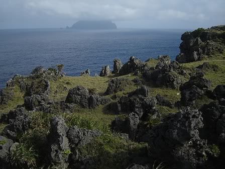
  • Ruins of Songsong 
  • A ghost barangay which is really a cluster of roofless shells of old stone houses abandoned after a tidal wave that hit the island of Batan in the 1950s. The area has a long stretch of beach. Located 23 kilometers from Basco.

  • Radiwan Point 
  • Located at Ivana Seaport, this is the landing site of the Katipuneros on September 18, 1898, thus making it a very historical location. The falowas plying the islands of Sabtang and Itbayat are also stationed here.
  • Other Places of interest in Batanes:
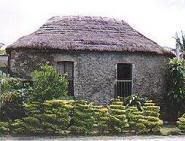
  • House of Dakay (1887) a UNESCO heritage building.
  • Lighthouses of Batanes
  • St. Dominic de Guzman Parish Cathedral
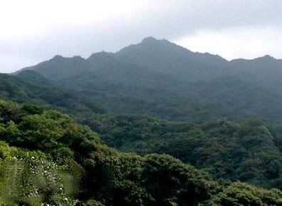
  • Mt. Iraya – A 1008-meter mountain on Batan Island.
  • Mahatao View Deck
  • Burial Caves – Pre-historic burial caves in the town of Itbayat.
  • Sumhao Wind Power Plant
  • Nakaboang Beach, Ark & Cave
  • Beaches – Chadpidan Beach, White Beach and more.
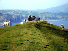
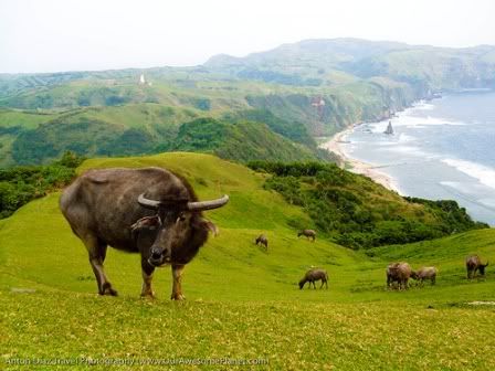
  • Payaman – known as “Marlboro Country”, a pasture overlooking farm fields & the Pacific Ocean.

Batanes Greening Program

0 comments


BASCO, Batanes, October 21 -- The Department of Agrarian Reform here has committed 1.5 hectares of public domain land for the Billion Trees and National Greening Program of the environment department.

According to Agrarian Officer Flordeliz Come, the said lot will be planted with trees for the period of six years, starting this year up to 2016.

Come said under the leadership of Provincial Agrarian Reform Officer Felix Alvarez, DAR has been extensively carrying out significant activities to support the NGP such as establishment of a nursery for seedling production and a tree farm at Rakuh a Payaman in Mahatao.

She also said that John Gato, DAR-Community Agrarian Reform program oficer has volunteered his lot in Sitio Malayo, Barangay San Antonio, Basco to be utilized as nursery for seedling production.

“DAR Batanes saw the need to establish a nursery for seedling production and preliminary activities
were done such as cleaning the area, potting and planting of seedlings of Arius, Mabolo and Palo-maria,” the agrarian official added.

A total of 1,600 seedlings were potted in June 2011 and 1,400 of it were planted the following month.
For the tree farm, MARO Agnes Viñas coordinated with Mayor Pedro F. Poncio of Mahatao, for a 1.8 hectare portion of the communal pastureland to be designated as permanent area for DAR and the Mahatao Agrarian Reform Beneficiaries association.

Kick off activity was the planting of two mango seedlings per employee and after a month, the fencing of the area was also done. Each employee also gave three posts and contributed an amount for the purchase of two rolls of barb wire to secure the area from astray animals.

Last month, the indigenous trees propagated at the nursery in Malayo Basco were traded with grafted carabao mango seedlings from the Department of Environment and Natural Resources. These, along with langka and guayabano seedlings were planted at the tree farm.

To date, an initial 1,400 seedlings have been planted at the tree farm and the DAR officials said through their regular schedule of tree planting, the completion of their target number of trees for the NGP will be fast tracked.

The DAR personnel are also continuously protecting and monitoring the status of the planted seedlings as well as continuous propagation of fruit-bearing seedlings, ornamental trees, local trees and hardwood trees. (Batanes Islands)

I-rice in NFA Batanes outlets

0 comments


BASCO, Batanes, October 15 -– National Food Authority (NFA) Chief Francisco Escalona announced that the I-rice is now available in all outlets of NFA here for P27 per kilo during the Provincial Disaster Risk Reduction and Management Council meeting recently.

Escalona said their warehouse has a stock of 4,000 bags of rice which is expected to last for two months and has been available in NFA outlets province-wide since the middle of September.

He further said that that another 4,000 bags of i-rice and ordinary NFA rice arrived in Basco through a cooperative cargo vessel.

NFA dealers were already rationed with their weekly 10 sacks supply; five sacks of ordinary rice
and five sacks of i-rice at 50 kg per sack.

Escalona said both varieties of rice are sold at P27 per kg.

Meantime, Editha Balles Surban of Barangay San Antonio here said she prefers i-rice for her family because aside from its low price at P27 per kg., which is much lower than the P45 per kg. of commercial rice, it is more nutritious than the ordinary variety. (Batanes Islands)

Typhoon Quiel in Batanes

0 comments

September 30, 2011


Weather forecasters said Friday Tropical Storm Quiel (international codename: Nalgae) intensified into a typhoon, posing threat to northern Luzon.

The Philippine Atmospheric Geophysical and Astronomical Services Administration (Pagasa) said in its 5 a.m. Friday bulletin that "Quiel" was at 770 kilometers east of Aparri, Cagayan at 4 a.m. 

The typhoon packed maximum sustained winds of 130 kilometers per hour (kph) near the center and gustiness of up to 160 kph. It is moving west at 22 kph.

Storm signal number one is hoisted over Cagayan, Isabela, and Babuyan group of islands.
Pagasa said the typhoon may make landfall in Cagayan Valley by late Saturday. 

With two high pressure areas ridging in at the Pacific, state weather forecasters said "Quiel" will be led to the provinces of Cagayan and Batanes this weekend.

A landfall is expected over these areas if the weather systems will not be dissolved soon, according to Graciano Yumul, supervising undersecretary of Pagasa.

A high pressure area, which brings good weather along its path, normally blocks the movement of a tropical cyclone in its intended direction.

"But we will continue to monitor for changes. So far, that is the consensus track," he told Sun.Star.
Typhoon Quiel is expected to enhance the southwest monsoon and will bring scattered to widespread rains over southern Luzon and western Visayas. 

The Pagasa also said another weather disturbance, Tropical Depression Ramon, is expected to enter the Philippine Area of Responsibility within two days after Quiel makes landfall and will hit northern Luzon.

Source: Sunstar Manila

Batanes Islands Geography

0 comments

Batanes lies on a group of islands collectively called Batanes Islands and they are the northernmost islands of the Philippines. They are located between the Babuyan Islands (belonging to Cagayan Province) and Taiwan. The islands are sparsely populated and subject to frequent typhoons.

The three largest islands are Itbayat, Batan, and Sabtang. The northernmost is Mavudis Island.

Almost one-half of Batanes are hills and mountains. Batan Island, with a land area of 35 km², is generally mountainous on the north and southeast. It has a basin in the interior. Itbayat Island, which has a total area of 95 km², slopes gradually to the west, being mountainous and hilly along its northern, eastern coast. As for Sabtang, mountains cover the central part of its 41 km² area, making the island slope outward to the coast.

The islands are situated between the vast expanse of the waters of Bashi Channel and Balintang Channel, where the Pacific Ocean, merges with the China Sea. The area is a sealane between the Philippines and Japan, China, Hong Kong and Taiwan. It is rich with marine resources, including the rarest sea corals in the world.

The province is hilly and mountainous, with only 1,631.50 hectares or 7.10% of its area level to undulating and 78.20% or 17,994.40 hectares varying in terms from rolling to steep and very steep. Forty two percent (42%) or 9,734.40 hectares are steep to very steep land.

Because of the terrain of the province, drainage is good and prolonged flooding is non-existent. The main island of Batan has the largest share of level and nearly level lands, followed by Itbayat and Sabtang, respectively. Itbayat has gently rolling hills and nearly level areas on semi-plateaus surrounded by continuous massive cliffs rising from 20–70 meters above sea level, with no shorelines. Sabtang on the other hand, has its small flat areas spread sporadically on its coasts, while its interior is dominated by steep mountains and deep canyons. Batan Island and Sabtang have intermittent stretches of sandy beaches and rocky shorelines.

The terrain of the province while picturesque at almost every turn, has limited the potential for expansion of agriculture in an already very small province.

The Province of Batanes

0 comments

The Province of Batanes (Filipino: Lalawigan ng Batanes) is the northernmost and the smallest province of the Philippines, both in terms of population and land area. The provincial capital is Basco.

The province is composed of ten islands, called the Batanes Islands, located about 162 km north of the Luzon mainland in the Luzon Strait and is part of the Cagayan Valley region in Luzon. Of this island group, the largest and only inhabited islands are Itbayat, Batan and Sabtang.

The Batanes Islands are separated from the Babuyan Islands of Cagayan Province by the Balintang Channel and from Taiwan by the Bashi Channel.

The northernmost island of the province, as well as of the Philippines, is Mavudis (Yami) Island. The other islands are Misanga, Siayan, Itbayat, Dinem, Batan, Sabtang, Ivuhos, and Dequey. Only the four largest islands (Batan, Ivuhos, Itbayat and Sabtang) are inhabited.

The Batanes are about 190 kilometers south of Taiwan.

 
Batanes Islands - Paradise of the North © 2005